Degrees Minutes Seconds Calculator - Convert Angles
The degrees minutes seconds calculator converts between DMS notation, decimal degrees, signed coordinate values, and decimal-minute format.
Degrees Minutes Seconds Calculator
Results
What This Calculator Does
The degrees minutes seconds calculator converts angular measurements between decimal degrees, DMS notation, and degrees with decimal minutes. These three formats describe the same angle, but they appear in different places: GIS exports often prefer decimal degrees, older coordinate records may use degrees-minutes-seconds, and navigation notes may use degrees plus decimal minutes.
The calculator accepts a signed angle, a direction such as south or west, or a decimal-degree value. It returns the normalized DMS form, the signed decimal-degree result, a decimal-minute version, and the equivalent radians. That combination helps compare a coordinate copied from a map label with a spreadsheet, GPS receiver, survey note, or astronomy reference.
A single-angle layout is intentional. Latitude and longitude often travel as a pair, but each coordinate follows the same conversion rule. Bearings, central angles, declination, and elevation angles also follow the same arithmetic when they are expressed in degrees, minutes, and seconds. Keeping the tool to one angle makes it easier to verify the value before it is placed back into a larger coordinate pair or geometry problem.
The output also separates notation from interpretation. A number such as -73.985656° may represent west longitude in a mapping record, but the same signed angle could represent a clockwise rotation or a negative bearing in another setting. The calculator shows the sign and the converted components without assuming a specific map datum, projection, or field standard.
For unit context, the angle converter handles broader angular units such as degrees, radians, turns, and gradians. For paired latitude and longitude entries, the coordinates converter supports complete coordinate records rather than one angle at a time.
According to NIST Special Publication 811, the radian is the SI unit for plane angle, while degree-based notation remains widely recognized for angle work. This calculator keeps those conventions visible without changing the underlying angle.
How the Calculator Works
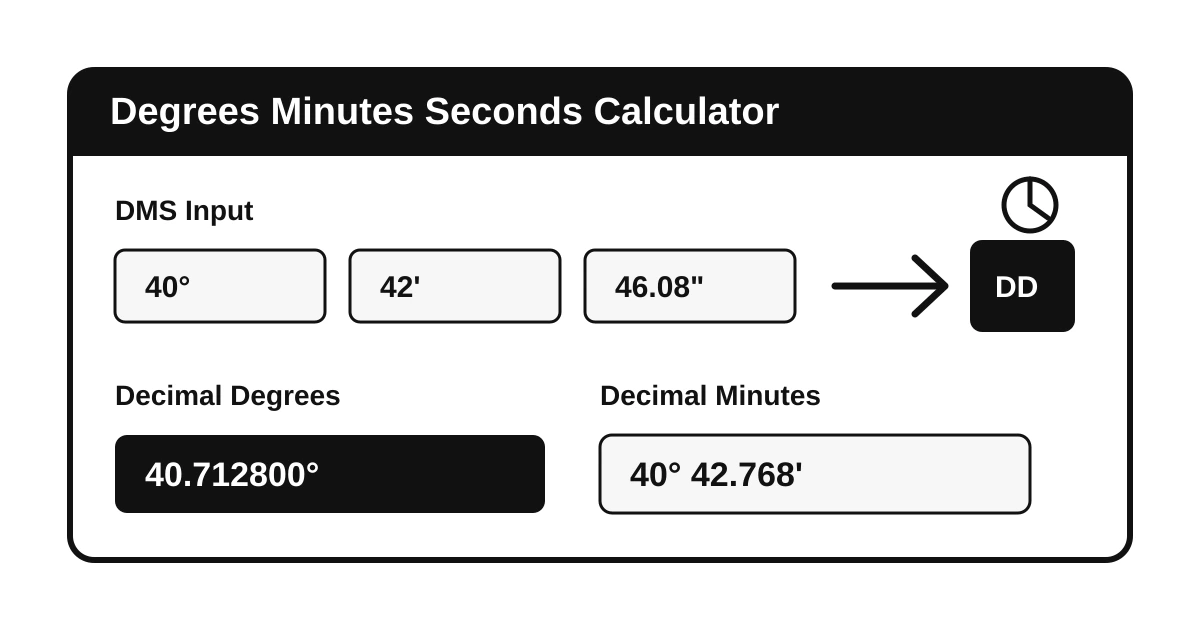
DMS conversion is based on a sexagesimal relationship: one degree contains 60 minutes, and one minute contains 60 seconds. The decimal-degree formula is decimal degrees = degrees + minutes / 60 + seconds / 3600. A negative direction is applied after those absolute components are combined, so 40° 42' 46.08" west becomes -40.712800°.
The reverse calculation separates the sign from the absolute decimal value. The whole-number part becomes degrees. The remaining fraction is multiplied by 60 to get minutes. The remaining minute fraction is multiplied by 60 to get seconds. Seconds are rounded for display, and a carry step prevents results such as 59.999999 seconds from printing as an invalid 60-second value.
A worked DMS example shows the scale clearly. For 40° 42' 46.08", the minute contribution is 42 / 60, or 0.7 degree. The second contribution is 46.08 / 3600, or 0.0128 degree. Added to the whole-degree component, the result is 40.7128°. A negative direction changes only the sign, so the same magnitude west or south becomes -40.7128°.
A reverse example starts with 51.5074°. The whole-degree part is 51. The remaining 0.5074 degree multiplied by 60 gives 30.444 minutes, so the whole-minute part is 30. The remaining 0.444 minute multiplied by 60 gives 26.64 seconds. The normalized DMS result is therefore 51° 30' 26.64".
The decimal-minute output follows a related formula: degrees plus (minutes + seconds / 60). This format appears in many navigation workflows because it keeps a whole-degree component while avoiding a separate seconds field. The conversion calculator covers general unit changes when an angle conversion is part of a wider measurement review.
NOAA National Geodetic Survey documentation for the OPUS API accepts latitude and longitude in either decimal degrees or DMS format for several search parameters. That official use case illustrates why careful format conversion matters in geodetic and mapping systems.
Key Concepts Explained
Degrees divide a full turn into 360 equal parts. Minutes and seconds of arc subdivide each degree, not clock time, even though they share familiar names. One arcminute is one-sixtieth of a degree, and one arcsecond is one-sixtieth of an arcminute. That structure makes DMS compact for precise coordinates because each field carries part of the same angle.
Decimal degrees place the entire angle in a single base-10 number. This format is easier for databases, APIs, spreadsheets, and formulas because ordinary decimal arithmetic applies. DMS is often easier for human inspection when a coordinate is printed, read aloud, or copied from older records. Conversion bridges those two strengths.
Degrees plus decimal minutes sits between those two formats. It preserves the degree field but stores the smaller subdivision as one decimal-minute number. For example, 40° 42' 46.08" becomes 40° 42.768'. This notation is common enough in navigation and field records that it is worth checking separately, especially when a receiver setting labels minutes with a decimal point but does not show a seconds box.
Radians are included because many mathematical formulas do not work directly in degrees. A radian measures angle through the ratio between arc length and radius, and a full turn equals 2*pi radians. The calculator's radian result is a companion value for trigonometry or circular geometry, not a replacement for the coordinate notation used in a source record.
Signs and directions carry location meaning for geographic coordinates. North and east usually represent positive values, while south and west usually represent negative values. The calculator treats direction as a sign choice and then performs the same angle arithmetic for either hemisphere. The coordinate plane calculator is useful when signed positions need x-y interpretation rather than latitude-longitude notation.
Precision should be chosen deliberately. More decimal places do not guarantee better original data; they only preserve more digits. A coordinate rounded to the nearest second is much coarser than one stored with several decimal places of seconds. The output therefore displays enough detail for checking while leaving final precision decisions to the source data standard.
How to Use This Calculator
For a DMS entry, the conversion mode should remain set to DMS to decimal degrees. The degrees field takes the whole-degree value, the minutes field takes values from 0 up to but not including 60, and the seconds field takes values from 0 up to but not including 60. The direction menu applies positive or negative orientation after the components are combined.
For a decimal-degree entry, the decimal mode reveals a single decimal input. A negative number is enough to mark a south or west coordinate. If the direction menu is set to negative as well, the calculator uses the negative orientation once, rather than doubling the sign. This keeps copied signed coordinates and direction-labeled coordinates from conflicting.
A practical review starts by identifying the source format before typing any numbers. A coordinate written as 40.7128 is already decimal degrees. A coordinate written as 40 42.768 has decimal minutes. A coordinate written as 40 42 46.08 has separate seconds. Confusing those last two forms is a common error because both contain a degree field and a minute-looking field.
The result should be copied with its sign or direction, not only its magnitude. A positive latitude can be labeled north, and a negative latitude can be labeled south. A positive longitude can be labeled east, and a negative longitude can be labeled west. When a destination system expects signed decimal degrees, the hemisphere letter should usually be removed after the sign has been applied.
After calculation, the result panel shows the same angle in four forms. Decimal degrees are best for code and tabular data. DMS is best for records that require separated fields. Degrees plus decimal minutes can match navigation devices. Radians support trigonometric formulas. The decimal to fraction calculator can help when a decimal component needs a fractional explanation for classroom work.
NOAA's VDatum user guide describes geographic coordinate input formats that include decimal degrees and degrees-minutes-seconds with decimal seconds. That makes a format check practical before transferring coordinates into coastal, elevation, or mapping tools.
Benefits and When to Use It
DMS conversion is most helpful when a value must move between human-readable records and software-readable data. A field crew may record a coordinate in DMS, a GIS table may require decimal degrees, and a report may need both forms for review. A single conversion reduces hand arithmetic and keeps the sign treatment visible.
The calculator is also useful for astronomy and geometry. Observational angles, declination values, and old reference tables may appear in sexagesimal notation, while calculations usually work better in decimal degrees or radians. Showing radians beside the DMS result helps connect traditional angle notation to trigonometric formulas.
Another benefit is auditability. A converted result can be checked by recomputing the minute and second contributions separately. This is helpful when a coordinate moves from a field notebook to a permit drawing, from a data logger to a CSV file, or from a printed table to an online form. Each part of the conversion remains visible enough to spot a misplaced sign, transposed minute value, or missing decimal point.
The calculator is also suited to teaching sexagesimal notation. Students can see why 0.5 degree equals 30 minutes and why 0.25 minute equals 15 seconds. That connection is harder to see when a coordinate converter only displays a final answer. Showing the decimal-minute and radian outputs beside DMS provides several views of the same angle without introducing a new measurement topic.
For mapping, the main benefit is consistency. Latitude ranges from 0° to 90° north or south, while longitude ranges from 0° to 180° east or west. The arithmetic is the same for both, but validation expectations differ by coordinate type. The calculator focuses on one angular value so the same workflow can be applied to latitude, longitude, bearings, or other angles.
When a converted angle feeds a curve or circular measurement, the arc length calculator can connect the angle to radius and distance along a curve. That follow-up is relevant when DMS data represents a central angle rather than a map coordinate.
Factors That Affect Results
The largest result differences usually come from sign handling. A west longitude written as W 074° 00' 21.60" and the decimal value -74.006000 describe the same orientation. Entering the DMS components as positive without choosing the negative direction will return the correct magnitude but the wrong hemisphere. The sign should be checked before the result is copied into a map or data file.
Rounding is another factor. Seconds rounded to two decimal places create a slightly different decimal-degree value than seconds rounded to six decimal places. A small angular difference can matter when coordinates are used for surveying, asset records, or geodetic comparisons. The displayed result should therefore match the precision of the source, not exceed it without reason.
Latitude and longitude limits should be reviewed outside the pure conversion when a geographic coordinate is involved. Latitude normally stays between 90° south and 90° north, while longitude normally stays between 180° west and 180° east. The same DMS arithmetic can convert a larger general angle, so a mathematically valid conversion is not automatically a valid geographic coordinate.
Source formatting can introduce ambiguity. Some records separate DMS fields with spaces, some use symbols, and some use compact strings such as N404246.08. Before conversion, the position of the degree, minute, and second fields should be identified from the source documentation. A compact coordinate without leading zeros can be misread, especially for longitude where three degree digits may be needed.
Invalid component ranges can also cause confusion. Minutes and seconds at 60 or above are not standard normalized DMS fields; they should be carried upward. For example, 12° 61' 0" is better written as 13° 1' 0". The calculator warns when minute or second entries fall outside the expected range so the source can be corrected before conversion.
Datum, projection, and coordinate reference system are separate from DMS notation. This calculator changes angle format only. It does not transform between WGS 84, NAD 83, UTM, state plane, or local grid systems. When those systems matter, a geodetic transformation tool should be used after the angle format has been checked against the original coordinate reference notes and any project documentation that defines the accepted coordinate standard.
Frequently Asked Questions
Q: What is a degrees minutes seconds calculator?
A degrees minutes seconds calculator converts angle values between decimal degrees, degrees-minutes-seconds notation, and degrees with decimal minutes. It is useful when coordinate records, surveying notes, astronomy tables, or mapping software use different angular formats.
Q: How is DMS converted to decimal degrees?
DMS is converted to decimal degrees by adding degrees plus minutes divided by 60 plus seconds divided by 3600. If the coordinate is south, west, or entered with a negative sign, the calculator applies a negative sign to the final decimal value.
Q: How are decimal degrees converted to DMS?
Decimal degrees are converted to DMS by separating the whole-degree part, multiplying the remaining fraction by 60 for minutes, and multiplying the remaining minute fraction by 60 for seconds. The sign is kept separately from the absolute angle components.
Q: Why must minutes and seconds stay below 60?
DMS is sexagesimal notation, so each degree contains 60 minutes and each minute contains 60 seconds. Values at or above 60 should be carried into the next larger unit before a coordinate or angle is recorded.
Q: Does DMS conversion change the actual location or angle?
DMS conversion changes only the notation, not the underlying angle. Rounding seconds or decimal places can slightly change the displayed precision, but the mathematical target remains the same angular measurement.